
There is something special about looking at a map before you ever set foot on the ground. Trace Africa on the world map, find the solitary peak that stands just south of the equator, then zoom in until the trails, camps and glaciers of Kilimanjaro appear. By the time you finish reading this guide, you will know exactly where the Roof of Africa sits — and which route will take you there.
Climbing Guide's Note
Every great climb starts with a good map. Understand where the mountain sits on the continent, how its three volcanoes shaped the summit, and which routes cross its five climate zones, and you'll arrive in Moshi already knowing why we climb the way we climb.
Finding Mount Kilimanjaro on the World Map
Finding Kilimanjaro on the world map is easy: start by locating Africa, almost divided in half by the equator. You will find a solitary mountain just south of the equator in the eastern part of the continent. Good landmarks include the largest African lake — Lake Victoria — and the border between Kenya and Tanzania. Kilimanjaro is right at the border, to the right of the lake.

Mount Kilimanjaro on the Map of Africa
On a map of Africa, Kilimanjaro stands out as a single isolated peak in the northeast of Tanzania, pinched between the Kenyan border and the plains below. More about where Kilimanjaro is located — and why some people look for the mountain in Kenya instead of Tanzania — can be found in the article where we share the coordinates of Africa's main attraction, among other interesting facts.

The Interactive Mt Kilimanjaro Map
For those who love details, here is the interactive Mt Kilimanjaro Map — surrounded by roads in northern Tanzania. Explore the layers, zoom in, and you will soon spot the trails, camps and the glaciated summit.
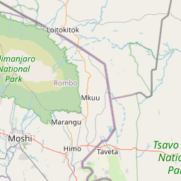


The extensive green area around the brown spot represents the mountain's slopes covered with rainforests. The light brown zone is the rocky summit, with no plants and thus no animals. It is located at over 5,000 metres (16,400 feet) above sea level.
A National Park
The map shows the mountain sits inside Mount Kilimanjaro National Park. From about 1,800 metres (5,905 ft), no people live on the mountain — its slopes are protected as a national treasure of Tanzania.
Zoom In Closer
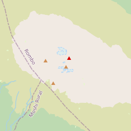
Zoom in on the map and you will see many interesting features: tourist camps, lodges for overnight stays, individual glaciers, and of course its highest point — Uhuru Peak.
Read the Colours
Green marks forested, living lower slopes; light brown marks the bare, lifeless summit world above 5,000 m. Between them run the five climate zones below — see our climate zones guide for what lives in each one.
Kilimanjaro Is a Volcano — Three, in Fact
To be more precise, Kilimanjaro consists of three volcanoes. The highest, whose summit everyone aims to reach, is the youngest and tallest — it is called Kibo. To the east of it is the Mawenzi volcano, which only professional climbers with technical equipment can ascend. The third volcano has almost completely eroded, but it once stood to the west of Kibo; today it forms the beautiful Shira plateau.

Kibo
The Highest & Youngest
5,895 m
The summit everyone aims to reach. Its crater rim holds Uhuru Peak, the highest point in Africa, together with the hidden Reusch Crater and Ash Pit inside the caldera.

Mawenzi
The Rugged Giant
5,149 m
Lying to the east of Kibo, Mawenzi is heavily eroded and technically demanding — only professional climbers with full mountaineering equipment attempt its Hans Meyer Peak.

Shira
The Ancient Plateau
3,962 m
Almost completely eroded by the eruption of the youngest volcano, it once stood west of Kibo. Today it forms the beautiful Shira Plateau, crossed by the Lemosho Route.
Each of the three volcanoes has its own highest peak: Johnsell Point (3,962 m / 12,999 ft) on Shira, Hans Meyer Peak (5,149 m / 16,893 ft) on Mawenzi, and Uhuru Peak (5,895 m / 19,341 ft) on Kibo.
Kilimanjaro Is the Highest Mountain in Africa
The height of Kilimanjaro is 5,895 metres (19,341 feet) above sea level — a number you will see on the stand at the summit and on the medals awarded to those who reach the main peak. Accurate measurements in 2008 gave a figure of 5,891.8 metres (19,330 feet), but that still makes Kilimanjaro the highest mountain on the continent. In Tanzania it is called the "roof of Africa".

Kilimanjaro Is Part of the Seven Summits
Being the highest mountain in Africa, Kilimanjaro is part of the Seven Summits — a group of mountains, each the highest for its continent or part of the world. The others are:
Aconcagua in South America
Denali in North America
Vinson Massif in Antarctica
Elbrus or Mont Blanc in Europe
Everest in Asia
Kosciuszko in Australia or Jaya in Oceania
Learn more about the Seven Summits and the people who "collect" them in our guide to the highest mountains in Africa.
A Popular Peak for Trekking Expeditions
Each year, more than 50,000 people aim for the summit of Africa's highest mountain. Among them are professional climbers and beginner hikers, who often combine the Kilimanjaro expedition with a safari in Tanzania's national parks. Arusha National Park is the closest safari destination, but many other iconic parks are close too — for example the Ngorongoro Crater or the Serengeti National Park that borders Kenya's Maasai Mara National Reserve.

You Can Head to the Roof of Africa at Any Time
Read our articles about Kilimanjaro and plan your expedition. Masatu Tours will be happy to organize your trip — from airport pickup to the summit sign.
The Slopes Are Divided into Five Climatic Zones
It is often said that climbing from the base of Kilimanjaro to the summit is like traveling from the tropics to the North Pole. That is because the climber crosses five different climatic zones on the way up.
Cultivation Zone (Up to 1,800 m (5,900 ft))
Where locals grow crops — banana, coffee and maize plantations on the fertile lower slopes.
Rainforest Zone (1,800 – 2,800 m (9,200 ft))
Tropical forest with high rainfall, monkeys, and towering trees dripping with moss.
Heath & Moorland (2,800 – 4,000 m (13,100 ft))
Unusual plants such as the Giant Lobelia and the Kilimanjaro Groundsel grow here.
Alpine Desert (4,000 – 5,000 m (16,400 ft))
A stark world of rocks, mosses and lichens where almost nothing else survives.
Arctic Zone (Above 5,000 m)
A stony desert with glaciers and snow, periodically covering the summit areas.

There Are Glaciers on Mount Kilimanjaro
At the summit of Kilimanjaro, just 340 kilometres (211 miles) from the equator, there are glaciers almost 12,000 years old. Today those ice structures are rapidly disappearing due to sublimation, melting and evaporation. Between 1912 and 2011 the glacier area decreased by 85%. Some glaciers have disappeared forever, while others are rapidly shrinking.
Kilimanjaro currently has three ice fields and 16 separate glaciers. The most famous are the Furtwüngler, Decken, Kersten, Rebmann and Drygalski Glaciers. It is expected that the last remnants of ice on Kilimanjaro will disappear by 2050.

Uhuru Peak — the Highest Point of Kilimanjaro
The highest point of Mount Kilimanjaro is Uhuru Peak, a small elevation on the edge of the outer rim of the Kibo volcano. Its official height is 5,895 metres (19,341 feet) above sea level, and it is the ultimate goal of every Kilimanjaro expedition. The word uhuru translates from the local Swahili language as "freedom", referring to Tanzania's independence gained in the 1960s.
Freedom, Literally
Standing on Uhuru Peak is a small, personal independence won one slow step at a time. Few signs on earth are photographed as often — or mean as much.
Mount Kilimanjaro Has Several Craters
Kilimanjaro's central volcano, Kibo, sits between the Shira plateau and the Mawenzi volcano, and its cone is 24 kilometres (15 miles) wide at the base. At the top of Kibo is a large crater 2.5 kilometres (1.55 miles) across, formed from a summit collapse 150,000–200,000 years ago.
After that collapse the volcano became active again, creating a new cone inside the crater called the Inner Cone, which measures 1.3 kilometres (0.8 miles) across. Within it lies the Reusch Crater, 820 metres (2,690 feet) in diameter, named after Gustav Otto Richard Reusch, who attempted the climb 65 times in the early 20th century. Inside the Reusch Crater is the Ash Pit, a 340-metre (1,115-foot) wide and 200-metre (656-foot) deep pit that serves as the main vent of the volcano. Read more about the Reusch Crater and its namesake.
Several Routes Lead to Uhuru Peak
To reach the summit you can take one of several official routes: the Lemosho, Machame, Marangu, Rongai, Northern Circuit, Umbwe or the Western Breach route. There are also variations such as the Shira route and Loitokitok, plus a Southern Circuit connecting Marangu with Umbwe.

Lemosho Route
Longest, most scenic climb and the most reliable acclimatisation profile we guide.
7–8 days
Explore the route
Machame Route
The popular 'Whiskey Route' with spectacular views across the mountain.
6–7 days
Explore the route


Northern Circuit
The longest route, circling almost the whole mountain for the best acclimatisation.
8–9 days
Explore the routeAll these paths can be used during the ascent, but the Mweka Route is used only for descent. The backup descent route is Marangu. Incidentally, Marangu is the only route with huts for overnight stays and permanent toilets — on all other routes, tented structures are used for camps. For a full comparison of every trail, read our complete routes guide and how long each route takes.
Our Honest Advice
If you have the time, climb for 7–8 days. The extra days are what let your body acclimatise — and acclimatisation is the single biggest factor in reaching Uhuru Peak. Pair your route with a training plan and the odds stack firmly in your favour.
Frequently Asked Questions
Mount Kilimanjaro is located in East Africa, in the United Republic of Tanzania, near the border with Kenya. Although the classic postcard views are shot from Kenya's Amboseli National Park, the mountain itself sits entirely inside Tanzania. If you plan to climb the highest mountain in Africa, look for flights to Kilimanjaro International Airport (JRO).
The nearest city is Moshi. It is the capital of the Kilimanjaro region where the mountain is located, and the second most popular tourist centre in Tanzania after Arusha. Moshi is the base for most climbs and has a small domestic airport. For international flights, most travellers fly into JRO (KIA) — Kilimanjaro International Airport — about 45 minutes from town.
An expedition normally takes seven days. There are shorter five-day trips for people already well prepared for high-altitude acclimatisation, and we recommend 6–8 days for regular climbers. If you want to spend a night in the Kilimanjaro crater, the expedition extends to 9–10 days. Longer routes give your body more time to adapt, which is why they summit far more reliably.
Compared with other mountains on the Seven Summits list, Kilimanjaro is not considered technically difficult — the standard routes need no ropes, ice axes or crampons. The challenge is altitude, and beginners usually struggle most during the last two days: the tiring summit push and the long descent. Almost any healthy person can reach Uhuru Peak. There is no official success rate, but based on our 10 years of experience the success rate on the recommended Lemosho Route is about 95%.
Yes. A healthy, physically active person without high-altitude climbing experience can complete the journey from the national park gates to Uhuru Peak. Our 10 years of experience confirm this: teenagers, elderly travellers, men and women, and even people with certain health conditions have climbed with Masatu Tours. If you have any health concerns, consult your doctor first to understand how your body will react to altitude.
No. The so-called death zone starts at about 8,000 metres (26,247 feet) above sea level, where the air contains too little oxygen for prolonged human survival. The maximum height of Kilimanjaro is 5,895 metres (19,341 feet) at Uhuru Peak, well below that threshold. Even so, altitude sickness is real and serious on the mountain, which is why a longer itinerary and careful acclimatisation matter so much.
Ready to Climb?
Book Your Kilimanjaro Climb
Compare routes and prices from our Moshi-based team, no middlemen, fast quote within 3 hours.
Related Kilimanjaro Guides
Where Is Mount Kilimanjaro?
Location, coordinates and the Kenya mix-up explained
Amazing Facts about Kilimanjaro
More surprising facts about the Roof of Africa
Highest Mountains in Africa
Kilimanjaro and the Seven Summits context
Which Route to Choose?
Every route compared in a Q&A format
How Difficult Is Kilimanjaro?
Honest look at the physical demands
How Long to Climb Kilimanjaro
Route-by-route durations and success rates
Ready to Turn That Map Into a Summit?
Last updated: September 9, 2026. Heights and glacier data based on current park records.
